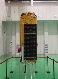
A Kuaizhou 1A rocket lifts off Saturday
from the Taiyuan space base with the Jilin 1 Gaofen 02B Earth-imaging
satellite.
The Jilin 1 Gaofen 02B spacecraft joins a
fleet of commercial Earth-imaging stations owned by partner CGSTL. The new
satellite is the 15th spacecraft launched in the Jilin 1 fleet since 2015, and
will be capable of collecting imagery with a resolution of better than 2.5 feet
(75 centimeters).
The satellite is mainly used for land
census, urban planning, land rights, road network design, crop estimation and
disaster prevention and mitigation, etc., and can provide information guarantee
for the construction of the Belt and Road and the modernization of national
defense.
The Jilin-1 High Resolution 02 satellites
features an imaging system with a resolution of 0.75 m in panchromatic mode,
better than 3 m in multispectral mode, an image swath of 40 km from a 535 km
high orbit. The satellites operate in pussh-broom mode and are capable of
imaging up to 45° off-track.
